Showing posts with label hiking. Show all posts

Friday, June 29, 2012

An island retreat [Vestmannaeyjar -- 3 days]

Figuring that if I'm spending a month on a big island, I ought to spend a few days on a tiny one. Boarded the 10am ferry boat for the 40min trip to the Vestmannaeyjar Islands just south of the mainland. This is a group of about 15 small volcanic islands formed during the last Ice Age (10-20,000 years ago) although the most recent one, Surtsey, was formed during an underwater eruption between 1963-1966. The largest island, Heimaey, is the only inhabited one and is home to over 4000 people. It's a popular destination for bird watchers and has quite a few of the famous puffins living on its cliffs.
The campground here [there are two actually- Porsheimili is far nicer than the other up the road] is really a great setting- overlooking a cool golf course built into a lava field, the ocean and several small islands; backed by an amphitheater of towering cliffs with swarming birds and a few errant sheep. I ended up settling in for 3 pleasant nights, enjoying the chance to rest, explore, soak and linger at the town coffeeshop.
Porsheimili campground

Early on the agenda was a nice soak at the town swimming pool, with an extra hot hottub. I was randomly given a locker for my valuables, and it was (appropriately) my old courier number from the past 8+ years:
lest I forget my past...
On my second evening as I was heading to the campground's communal kitchen area, a nice Polish couple I'd met earlier were hanging out at the picnic table. Upon my arrival the exclaimed, "Come, we have made you fish! Eat dinner!" This was no joke- they'd been down at the fishing docks trying to buy a fresh fish for dinner. The fisherman must've liked them and said, "We have plenty, here take these two for free" and handed over two big fish (cod and haddock) that were so fresh they had yet to even be packed into the ice chests. Talk about a score for me! We had a little campground feast with several others, and the fish was deliciously grilled with garlic butter and lemon. I'd been intent on eating some fresh Icelandic fish, although was reluctant to fork over the $40+ most nice restaurants were charging for a good seafood meal. Talk about a bargain!
catch of the day
the Chefs of Honor- Mia & Lukas from Poland
The next day I rode the couple of miles down to the southern tip of Heimaey to what is, statistically speaking at least, "the windiest place in all of Iceland." The weather station here at Storhofdi records only an avg of 4 calm days per year and often has winds over 30m/s. It was only a gentle breeze today, however.
Storhofdi
Along the way I watched some killer whales coming up for air as they feasted on fish schools a ways off the coast. I didn't spot any puffins, although I didn't really go searching them out like most visitors do. Guess I've never been much of a bird watcher. Next it was up to the northern tip of the island by the harbor to climb the island's highest point, Heimaklettur, at 283m above sea level. The views were pretty cool, especially of the lava field created by a 1973 eruption that evacuated the island, buried 300+ homes, added 2.3 sq km of land mass and threatened to block off access to the harbor. I'm told some of the lava is still hot enough to light a cigar from the ground, although I did not test this out personally.
sheep ain't afraid of heights!

Sunday, June 24, 2012

A tailwind is a terrible thing to waste [Skaftafell > Vik -- 86mi ]

The Svenafell campground where I stayed last night was just a few miles from the Skaftafellsjokull glacier, a popular tourist destination with a nice Visitors Center and some scenic hiking to be had. It was busy by Icelandic standards but worth the stop. There was a lot of interesting info on display at the Visitors Center about the geology and history of the region, and I'm always a sucker for those kinds of things.

First I took the short, paved path up to the edge of the glacier. I'd hoped to be able to actually walk upon it, but a pesky fast flowing (and very cold!) river cut off access onto the ice. [Back in Denver, my old buddy Robbie gave me a couple of the amazing chocolate bars that he makes at Ritual Chocolate... on the condition that I snap a few photos of his culinary work in Iceland- and then enjoy them! BTW, this is seriously the best chocolate ever!! They spend several weeks hand making it with vintage machinery from the 1920's, then age it in blocks for many months before finally creating a finished product. If you see a Ritual Chocolate bar for sale, seriously, splurge on it and you will not be disappointed!]
Ritual Chocolate and the Skaftafellsjokull
I then hiked up the ridge overlooking the glacier:

Skaftafelssjokull
On the way back down, low and behold I got to walk amongst some trees for the first time on this island!
After eating my lunch at the Visitors Center, I pushed off around 6:15PM to make some more headway this evening. Not everything in Iceland is picture-perfect postcard scenery:
Skeidararsandur
This is a vast, perfectly flat ~20mi stretch of black sand/gravel which is considered a glacial floodplain. The glacial floods are an interesting phenomena: there are actually lakes submerged beneath/within the large glaciers, and the underground volcanic activity gradually melts some of the glacier from the inside. As ice floats on water, eventually the water levels rise high enough that the glacier is lifted up enough to release excess water from within. Some places this occurs annually, others it is only a rare happening. And of course when a volcano actually erupts, it melts the glacial ice very rapidly and serious flooding follows. So these vast flat floodplains are a result of this process over tens of thousands of years.

I passed through several miles of a cool lava field covered in white pillowy moss- it looked like it had rained marshmallow fluff:
Brunahraun
I got a little town with a big name, Kirkjubaejarklaustur (typically abbreviated to Klaustur) and figured I'd set up camp somewhere comfy nearby. But just outside town I discovered I had a really nice tailwind, and if I've learned one thing about cycling here it is you never waste a good opportunity to make friendly with the wind. So I pressed on for another hour, then another-nuther hour, eventually 35mi beyond the town and only 9mi before the next town of Vik. It's not everywhere you can set off at a normal person's dinnertime and burn down 80+mi before going to bed!

Sunday, June 17, 2012

2 days exploring Myvatn on foot

Ended up spending three nights at the lakeside campground in Myvatn; it's a fascinating place bustling with volcanic and goethermal activity. I easily could've spent an entire week or more and still not had time to hike to everything to see around here. Myvatn is also one of the biggest bird sanctuaries in the world and I think I read that there are somewhere around 2000 different species of birds living around the lake.

The first day Craig, Karolyn and I set off to hike up to a volcanic "psuedo-crater" [they are called psuedo-craters, because they look like craters but that term implies creation by impact (meteorites) rather than by volcanic activity. There are many of varying sizes in this area.) Along the way we turned up an amazing little natural hotspring cave along the trail.

At this point it was raining pretty steadily and looked like dark clouds would be bringing more for the foreseeable future. So instead of hiking up to the pseudo-crater in the wet, we took the other fork in the trail to the Myvatn Nature Baths, a "luxury" hotspring resort said to rival the world famous Blue Lagoon rear Reykjavik. It cost a pretty penny to get in (2800 Krona... ~$21) but seemed worth the splurge. It was. Of course by the time we hiked to the springs, the rain had stopped but the idea of a lazy afternoon soaking in hot mineral water sure sounded splendid.
Myvatn Nature Baths
At the cafe there, I got to try Bjarnarflagsbraud ("Geyser Bread") a local specialty that is baked underground for 24hrs using the natural geothermal heat nearby. It's an interesting bread and quite tasty actually- it's extremely dense but soft and sticky and very savory.... like the heaviest gingerbread ever, minus the ginger and sugar.

A few hours in the hot pools did the body good (and the skin too, according to advertisements) so we started back to camp and checked out some crazy features along the way.
geothermal power plant & cooling pond


Day 2: On Sunday I set off solo to do some more exploring. First I rode around the west shore of the lake to hike the summit of Vindbelgarfall volcano for a nice view of the surrounding area and many pseudo-craters around the lake.
 

After a mountaintop lunch, I pedaled back around to the east shore and hike to the rim of Hverfjal volcanic rim. It's hard to tell from the photo but the rim ridge runs in a complete circle that you can easily walk all the way around.
Hverfjal
We'd also made friends with a couple of British ex-pats now hailing from Canada who are traveling counter-clockwise around the island via public bus. They've been spending a few days at the Myvatn campground as well and we've had many lingering breakfast & dinner conversations in the communal kitchen area; this last night here was no different.
good company: Karolyn, Graham and Jane


Tuesday, May 22, 2012

4 day Mini Tour: Denver > Longs > Ned > Boulder > Denver

My last big push physically before my 3 month summer tour begins- and more importantly I think, a trial run with the 'new' bike and my gear setup. Set up the bike last weekend, packed up on Wed/Thurs and I took a 'vacation' day Friday and hit the road at 7am headed west.


My agenda for the long weekend: bike tour to Longs Peak, hike to the summit of Longs, ride to Nederland and then find my 'puter seat in the courier office on Monday morning.

I elected to climb via Golden Gate Canyon, the most direct route onto the Peak To Peak HW. It is a long, long climb... a few years ago when I was "training" for my first Utah Tour, I tried to climb this road, sans gear. I had to surrender to bowing my head over my bars near the top of the long ascent. Yet today I, smugly, crushed it. 50lbs of gear and I made a steady snail's pace up into the upper edge of the Foothills. Not to brag, but all my training has really paid off! I used to think that working as a courier counted as training. False. Very false. Since early January, you could say I've been sorta focused on training, 5-6 days/wk... running, swimming, weights, yoga, some spin classes, a few weights/spin/yoga (what the hell is that?) and of course many long rides in the mountains made possible by the unseasonably warm and dry winter we had.

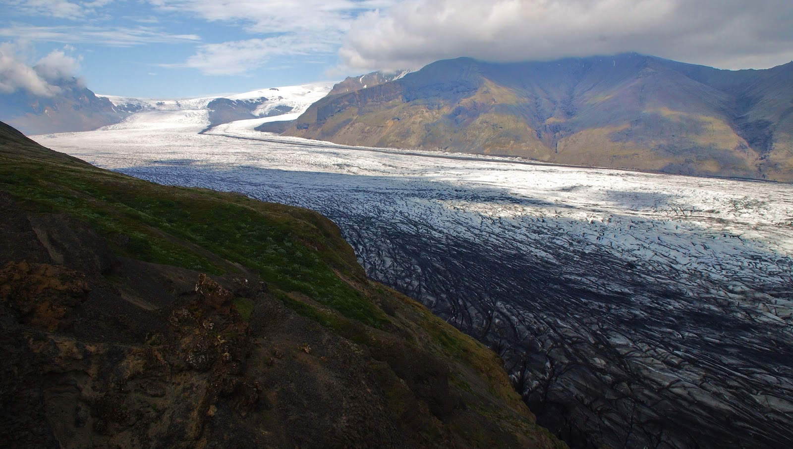
So after 16mi of rolling flats and 18mi of of climbs, I finally gained the Peak To Peak HW

From here I headed north on the P2P for ~50mi, undulating between 8K and 9.4Kft  through Nederland, Ward, Allenspark. Shortly prior to the Longs trailhead/camp turnoff, I stopped by Olive Ridge campground and met Roland & Margaret, a retired Swiss couple halfway through their year long RV tour from Buenos Aires to Alaska to NYC! They shared a beer (american Budweiser) as we chatted about my euro tour and art museums near Basel, their hometown.
 
Despite threatening rain clouds all afternoon, I arrived dry at the Longs Peak campground, still closed for the winter, around dusk. Some overnight storms brought rain, lightening and sleet and I packed up camp still encased in ice at 5:30am Saturday morning. 82mi and 9900ft gained my first day out with full gear.

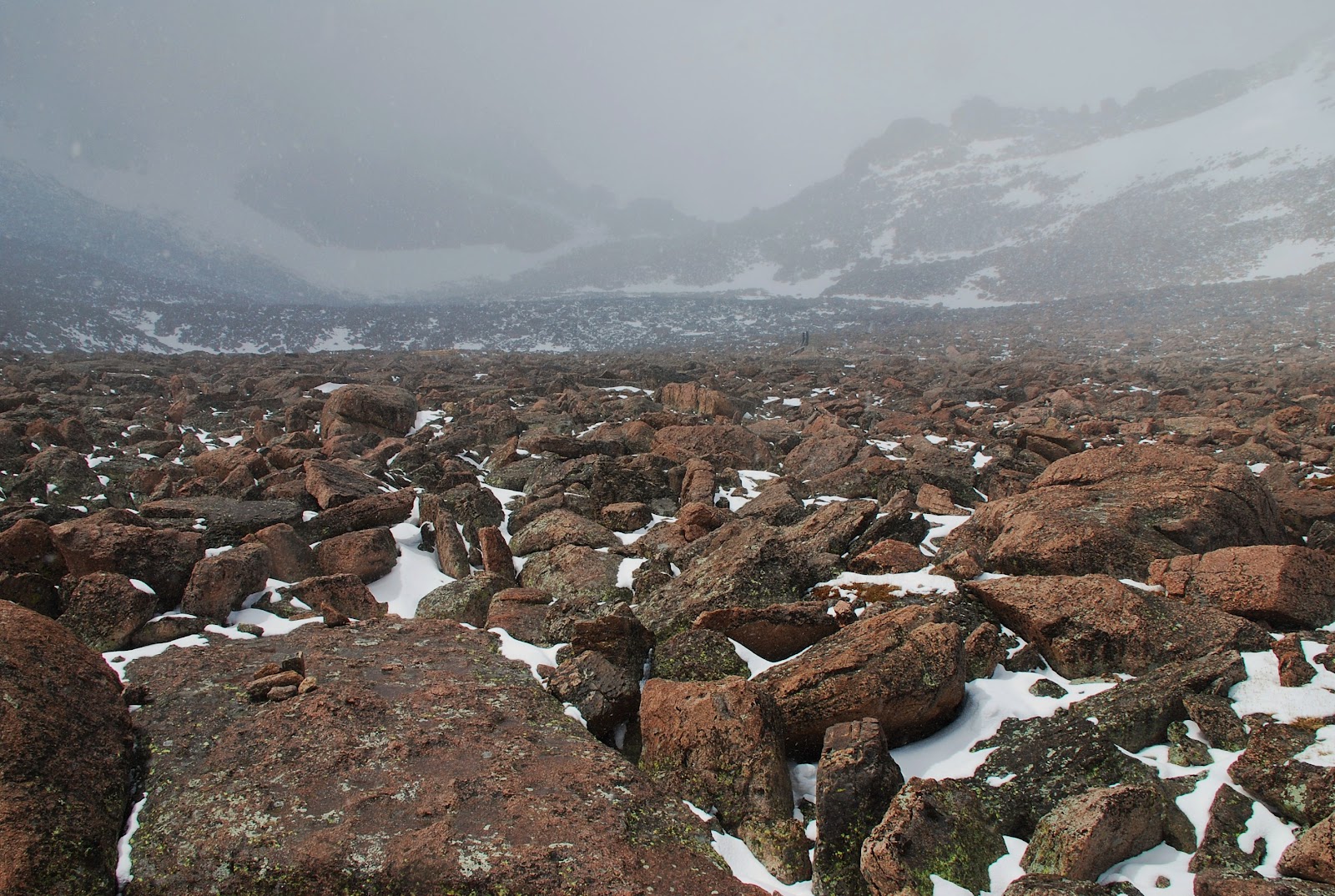
Hit the 7.5mi (each way) Longs trail at 7am on foot and climbed above a beautiful inversion

The weather was spotty; snow flurries w/o accumulation all day. A few times I considered turning back but each time I'd stop to regroup, the clouds would start to break before I was ready to turn tail. And so I kept pushing up and ahead. Until I got through the boulder field and saw a tent, I'd been the only person hiking up this high today.
the "trail" through the boulder field en route to The Keyhole
I pushed through 'The Keyhole' and things started to get far more intense in terms of climbing, altitude and weather. The signs had warned that this was "not a hike" rather a "climb" and I finally began to understand their advice. The backside of The Keyhole was no joke; one wrong slip would send you sliding down into dire consequences!
The Keyhole
The red/yellow bullseye paint marks the "easiest" route to scramble beyond The Keyhole.

Traversed the west ridge and caught up to two Tennessean brothers while ascending "The Trough." Now that I wasn't alone up here in the dicey conditions, all three of us pushed onward through "The Notch" and across "The Narrows." The snow was picking up and starting to accumulate, and the warmer rock faces were beginning to freeze over. Things were getting messy and dangerous. We made it to the very last steep pitch before the Summit Ridge when one of the brothers looked ahead and murmured, "This is stupid."

We all agreed. One slip, which was increasingly likely, would lead to instant death as you cascaded off the cliffs below. We turned back at 13,900ft, just 350ft below the summit. Wise decision... wiser yet would have had us heading down much sooner. There were no epic views, no grand ski lines, no majestic summit. We were just experiencing it for what it was, but that was perhaps better than running into a trail traffic jam on a bluebird day with people streaming onto the summit.
13,906ft
  The return back to the Keyhole was harder than the climb up because the continuing snow/wind was covering our tracks as well as the painted route markers. And shit was getting slick! We progressed very slowly and cautiously with only a few scares; when the Keyhole came into view all 3 of us let out a howl of relief. The risk had not abated entirely, but the worst was behind us. I made haste down the mountain towards my bike/gear so I could ride back down to the Natl Forest campground 6mi south. The sky was still dropping flakes when I returned to the trailhead at 9400ft, but the storm was breaking up and I let out for the other campground where I knew I'd have the next day for the 'dryer cycle' aka Colorado sunshine!

As I dried, organized and hashed out my gear, I had the realization that this stuff, give or take a few items, will be my only worldly possessions for the next three months halfway around the world. I think I'm comfortable with this prospect... certainly wish I didn't have an apartment full of crap to deal with.

In the afternoon I hit the road again and headed south on the P2P HW for 35mi to camp in the National Forest near where I often go mountain biking. Weather squalls missed me again; 2 out of 3 ain't bad. In the early morning I packed up and rolled into Nederland for a morning coffee before jamming down the canyon to work dispatch duties in the courier office.

After 9 hours in the office, it was back to the road to ride home to Denver through the 'burbs. A very successful 4 day trek! About 175mi on the bike and almost 15mi of high alpine hiking for the long weekend.

Friday, April 13, 2012

Friday evening half-marathon run

The weather forecast killed my challenge to see how many consecutive century ride weekends I could string together, so I decided to do a long run on Friday instead. I started out aiming for 10mi (I normally do a ~6mi tempo run) but once I got going, figured "what the heck, let's just do a half marathon." And so I pressed on.

I've never been much of a runner, never participated in the Track & Field or Cross Country teams in high school and generally regarded running as slow, boring and hard. Until last year, when I decided I ought to incorporate running into my workout routine as a form of cross training. I also wanted to do some impact exercise, as cyclists are at risk of developing bone density problems later in life because our bones have it so easy on smooth spinning bikes all the time. So I started running once a week and found that I actually enjoy the time a lot- it's a great cardio workout, a nice time to devote to listening to music and my thoughts and the chill redundancy provides a very relaxing yet taxing platform to settle into. I'm still no star runner, but have improved a lot and value my weekly runs on the South Platte River bike path.

I wouldn't have guessed I could've ever run over 13mi in one session, but kept going until I'd done it. I was tired by the end, my calves and feet hurt and my legs were exhausted. I felt great! Not a bad way to spend a few hours after work on a Friday night, yes?

Wednesday, April 11, 2012

Wednesday evening hike on Indian Creek Trail

My friend Lucy wanted to go for a hike (she's car-less, I provided the transport and she provided the motivation.) T-storms rolled into Denver that afternoon, it hailed briefly, we went anyway. We attempted to get to a trail west of Sedalia (southwest of Denver) she knew that leads to an old fire watchtower... however the access road was closed for forest maintenance. So we continued up HW67 for a minute and found the Indian Creek Trailhead. I'd ridden this same road a couple weeks ago, just before a week before the Lower North Fork forest fire broke out in the area I'd ridden through. Today was a pleasant post-rain hike for a couple of miles through a recently thinned forest... and came to a neat vista in the late evening light.

We'd hit a perfect storm-less window, as Denver was treated to another round of boomers after I got back home. Fantastic to get out of the city and into the woods after a Wednesday workday.

Scrub Oak patch looking south from Indian Creek Trail summit in Jefferson County

Sunday, March 4, 2012

East Portal snow hike & Frozen Dead Guy Days

April & I decided months ago that it's time to forge our own paths in life for the foreseeable future. It's a mutually positive decision and we both want to move ahead individually. We've had a lot of good treks together; this was something of an encore before she moves into her new apartment next weekend. As they say, it's all good.

We drove up past Rollinsville to the East Portal of the Moffat Tunnel for a snow hike into the woods. We packed snowshoes but the trail was sufficiently packed to hike with our boots alone. The 6.2mi long Moffat Tunnel was completed in 1928 and allowed trains to pass beneath the Continental Divide; the trip was shortened from 4-8 hours to just 20 minutes via the tunnel, thus allowing safe, reliable and speedy passage to the West through Colorado. Today it's still used frequently by freight trains and the AMTRAK California Zephyr line.

There is access to lots of backcountry skiing and hiking from this area, although we were short on time and only hiked up to the west for about an hour before we had to turn back. Always nice to be out in the mountainous woods regardless.

Not far away in the town of Nederland was the annual Frozen Dead Guy Days festival, which we'd wanted to check out for the past several years but always somehow missed. The legend goes that there is an old Norweigan man who believed in cryogenics, and he is frozen in a shed awaiting the science to reanimate him when the time is right. Translation: a weird old man inspired a good ol' winter mountain party. They host a slew of events like Coffin Races, Frozen Turkey Bowling, a Hearse Parade and live music, beer garden, etc. The festival turned out to be less fun that we'd hoped, but at least we went.
Coffin Race course & spectators (and medical support)
heaving a frozen turkey towards snowy bowling pins
It was a good day, although in hind sight it would've been more rewarding to spend a full day hiking up somewhere more remote rather than milling around the festival. But alas, we went and experienced and that was good. Time to move on, anyway.

Saturday, January 28, 2012

Georgetown ice racing & snowshoeing Naylor Lake

Every other weekend in the winter months, there is a group of dedicated motorheads who race their 4x4's on the thick ice of Georgetown Reservoir along I-70 at about 8500ft. I'd heard of these events but finally made it up to spectate. What what a crazy event it is! We made it just in time for the "Cheater" Class of racing, which is basically the all-out customized purebred element of these guys. Most of them use old Jeep chassis retrofitted with incredibly suped-up V-8 engines powering tires sporting 1.5 inch spikes for traction as they race around a course of roughly eight turns. It's loud, it's powerful, it's excessive, and it's American for better or worse. I loved it, naturally.

 
After getting our fill of guttural powersports, we drove (in my stock 95 Civic) a ways up Guanella Pass and strapped on the snowshoes for a late afternoon hike up to the solitude of Naylor Lake.

I like the dichotomy of this trip to the mountains: the gluttonous excess of horsepower and pollution from the racers and then the utter quiet isolation of watching the sun set from ice at 11,000ft. We were literally the last people on the trail; didn't encounter another soul on the way up or down, and did the last half of the hike out to the trailhead with our headlamps guiding the way. It was sublime.